
Tuolumne County - a classic California gold locality famed for sculptural native gold and gold-in-quartz, with placer and lode finds prized by collectors.
Key facts
Tuolumne County is one of the classic specimen-gold names of the California Mother Lode, but its importance is broader than the romance of Gold Rush history. For collectors, the county sits at the junction of several distinct gold environments: the great placer basins around Columbia, Jamestown, Sonora, and Table Mountain; the hard-rock quartz-carbonate lodes of the Mother Lode belt; the parallel East Belt mines around Soulsbyville and Confidence; and the famous Pocket Belt, where small, discontinuous seams could yield astonishingly rich bursts of coarse native gold. The specimens that made the county collectible are not anonymous placer grains but sculptural masses of native gold: bright yellow leafs, ribbons, hackly plates, crystallized edges, and gold-in-quartz pieces with the white vein quartz still attached.
Geologically, the county is a cross-section through the western Sierra Nevada gold belts. The principal lode mines occupy a northwest-trending mineralized zone, with Mother Lode deposits along the southwest side near the great regional structures of the foothills, East Belt deposits farther northeast, and the Pocket Belt between them. The ore is the familiar but highly variable California assemblage of quartz, carbonate, mariposite-bearing altered wall rock, pyrite, native gold, and locally silver and telluride minerals. Around Jamestown, the gold-bearing system is tied to the Melones fault zone and to altered, sheared rocks that include quartz-carbonate-mariposite schist, serpentinite, and graphitic slate; at Columbia, the richest early gold was won from gravels caught in irregular limestone and dolomite bedrock pockets.
Historically, Tuolumne County was among the richest of California’s placer-gold counties. Its surface gravels drew miners almost immediately after the first wave of 1848 discoveries, and by 1850 places like Woods Creek, Sonora, Jamestown, Columbia, Chinese Camp, Shaws Flat, Tuttletown, and Big Oak Flat had become part of the Southern Mines. Later, as the shallow placers declined, the focus shifted to quartz mining, drift mining beneath Table Mountain, and then modern open-pit work at Jamestown. This long production history is why Tuolumne labels appear on both old-time cabinet specimens and modern crystallized-gold pieces.
Regional View
Country View
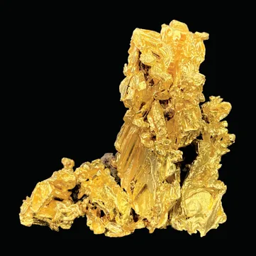
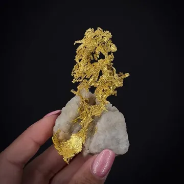
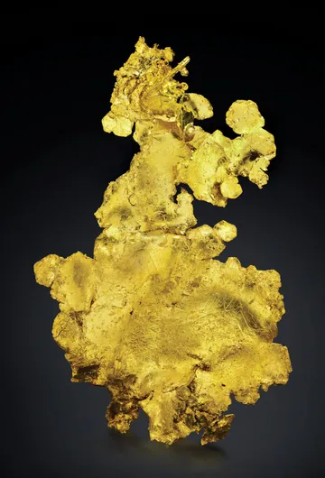
The best Tuolumne specimens have a particular look: leaf gold that appears folded or torn like foil, reticulated gold grown along seam openings, hackly crystallized masses emerging from vugs, and gold webbing through milky white quartz. Limonite staining and black telluride-rich patches can add character when they are original, but the most desirable pieces preserve three-dimensional natural form rather than being simply sawn, polished, or acid-cleaned down to bullion shape.

Photo: Wikimedia Commons

Photo: Wikimedia Commons
Search for specimens: View all specimens from Tuolumne County, USA
Tuolumne County’s collector localities are best understood as several overlapping gold districts rather than a single mine. The county lies in the central Sierra Nevada foothills, between Calaveras County to the north and Mariposa County to the south. Nearly all of its significant lode mines occupy a northwest-southeast belt roughly fourteen miles wide. The Mother Lode belt lies on the southwestern side of this zone; the East Belt lies to the northeast; and between them is the Pocket Belt, a chain of small but locally spectacular high-grade deposits.
The hard-rock deposits are orogenic quartz-carbonate gold systems hosted by sheared and altered metamorphic and ultramafic rocks. Around Jamestown and Sonora, massive quartz veins, quartz stringers, ankerite-quartz-mariposite rock, mineralized schist, serpentinite, and graphitic slate appear in close association. The gold occurs as native metal in quartz and altered wall rock and also with pyrite; silver and tellurides occur locally. The Harvard orebody at the Jamestown Mine, one of the best-studied modern sites in the county, lay along the Melones fault zone and became the largest of several open pits worked by Sonora Mining Corporation in the late twentieth century.
The placer story is equally important. Columbia Basin, Jamestown, Sonora, Table Mountain, Chinese Camp, Montezuma, and the Tuolumne River camps were fed by gold eroded from lodes and older auriferous gravels. At Columbia, miners worked an unusual and immensely productive basin underlain by crystalline limestone and dolomite of the Calaveras Formation. Gold-bearing gravels lay in potholes, crevices, and natural riffles in the bedrock surface, so the limestone itself became part of the mining machinery: every pocket, groove, and pinnacle was searched. Around Jamestown and Sonora, Tertiary channel gravels were worked by drift mines, especially where the old channels were protected beneath the resistant volcanic cap of Table Mountain.
Production figures show why Tuolumne remains one of the central names in California gold. Before 1899, the county produced more than seven million ounces of placer gold, much of it from the Columbia Basin and the Table Mountain channel system. Through 1959, total county production is estimated at more than ten million ounces, with placer gold far outweighing lode gold in total ounces. In the Columbia Basin-Jamestown-Sonora area alone, total production was estimated at about 5.9 million ounces. Lode mining became increasingly important after the richest placers were exhausted, especially after 1903, and the Harvard, Jumper, Rawhide, Golden Rule, Soulsby, Confidence, Bonanza, and McAlpine names recur in both mining and mineralogical literature.
The Pocket Belt is the county’s most romantic and specimen-relevant subdivision. It extends between the Stanislaus River and the Jamestown-Sonora area and is known for narrow, irregular seams of quartz and calcite cutting fractured Calaveras Formation rocks. These seams were not broad, predictable ore shoots; they were discontinuous pockets, locally swelling into fantastically rich zones of coarse gold. Some pocket gold is crystallized, and some is accompanied by tellurides such as petzite, calaverite, altaite, and related species. That geological discontinuity explains both the beauty and the scarcity of fine Tuolumne pieces: a small pocket could produce a remarkable suite, while adjacent ground might be barren.
Mining history here begins with 1848 discoveries on Woods Creek and other streams, followed quickly by Sonora, Jamestown, Tuttletown, Don Pedro’s Bar, Shaws Flat, Jacksonville, Chinese Camp, and other camps. Columbia was founded after the March 1850 Hildreth party discovery and rapidly became one of the richest and best-known placer camps in California. The East Belt developed soon afterward, with mining around Soulsbyville, Confidence, Independence, Payboy, and related properties. Soulsbyville is especially important because it was founded around lode mining rather than placer mining.
Modern mining reshaped the Jamestown area. Sonora Mining Corporation operated open pits at the Jamestown Mine between the mid-1980s and 1994, processing roughly seventeen million short tons of ore and producing about 660,000 troy ounces of gold. The Harvard pit, developed on the site of the older Harvard Mine, reached large open-pit dimensions and later filled with water, becoming the subject of USGS environmental studies because of arsenian pyrite and pit-lake geochemistry. From a collector’s standpoint, the modern period matters because it produced some of the finest documented crystalline leaf gold ever recovered from the county, including the celebrated Christmas pocket of 1992.
Collecting access today is highly constrained compared with the nineteenth century. Many historic mines are private, reclaimed, inaccessible, unsafe, protected as cultural resources, or located within parks where collecting is prohibited. Columbia State Historic Park preserves a living Gold Rush town, not a collecting ground. National Park Service lands, including Yosemite National Park, prohibit ordinary recreational collecting of rocks and minerals. On BLM and National Forest lands, casual rockhounding and gold panning may be possible only where not otherwise restricted, not on active claims, not in protected cultural or natural-resource areas, and not with mechanized disturbance unless separately authorized. Serious collectors should treat old Tuolumne mine labels as historical specimens, not as invitations to enter workings.
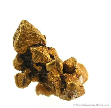
Gold from Tuolumne County is prized for native leaf, ribbon, hackly, crystallized, and gold-in-quartz habits, especially from Jamestown, the Pocket Belt, and the Columbia-Sonora area; the best pieces show bright yellow, three-dimensional natural gold rising from white quartz or limonite-stained vein material, with visible crystallized edges or folded sheet texture rather than merely heavy bullion mass. Small thumbnails and miniatures from the district can be excellent, while cabinet-size and larger pieces are genuinely exceptional; the modern Jamestown Christmas pocket proved the upper end of the size range with more than 1,500 ounces of specimen gold and a largest piece measured in tens of kilograms. Associations include quartz, limonite/goethite after pyrite, pyrite, mariposite-bearing altered rock, and locally tellurides such as hessite, petzite, calaverite, and altaite; good locality pieces are separated from ordinary placer gold by retained vein context, undamaged leaf form, old provenance, and a convincing mine or district label.
Quartz is the defining gangue mineral of Tuolumne County’s lode-gold specimens, occurring as massive milky vein quartz, vuggy white quartz, drusy surfaces, and locally rock-crystal material in gold-quartz veins and altered quartz-carbonate-mariposite rock. Collectors value Tuolumne quartz chiefly when it carries visible native gold or tellurides, because plain vein quartz from the county is common and usually of modest display interest; the best quartz specimens show open cavities with bright hackly gold, white contrast against leaf gold, natural limonite-stained vug texture, or sharp evidence of the original vein structure. Historic records also note rock crystal from local mines such as the Eureka-Grizzly area near Big Oak Flat, but in the specimen market “Tuolumne quartz” usually means the matrix that frames the county’s native gold.
Other documented Tuolumne County minerals include pyrite, arsenian pyrite, galena, sphalerite, chalcopyrite, acanthite, hessite, petzite, altaite, calaverite, sylvanite, native silver, electrum, cinnabar, bornite, barite, calcite, dolomite, ankerite, mariposite-bearing muscovite, malachite, azurite, mimetite, chlorargyrite, choloalite, keystoneite, owyheeite, and annabergite. The county’s most important rarity is mcalpineite, Cu3TeO6·H2O, whose type locality is the McAlpine Mine in Tuolumne County; it was described as emerald-green cryptocrystalline crusts on white quartz, associated with a complex telluride-rich metallic assemblage. Altaite is especially notable at the Barney Pocket Mine near Sawmill Flat, where classic accounts describe crystals cemented by gold.
Tuolumne County gold is a provenance-driven field. A generic “California gold” label is not enough for high-end collecting; the strongest pieces retain a specific mine or district attribution such as Jamestown Mine, Harvard Mine, Alabama Claim, Jumper/Golden Rule, Rawhide, Columbia district, Pocket Belt, Bonanza Mine, McAlpine Mine, or Soulsbyville. Because the county contains both placer gold and lode gold, the label should fit the specimen: waterworn nuggets belong to placer settings, while sharp leaf gold in quartz, vuggy seam gold, and telluride-bearing pieces should have a hard-rock or pocket-gold context.
The most common condition issue is preparation. Much California lode gold has been acid-treated to remove quartz, iron oxides, or carbonate and expose more gold. Careful cleaning is not automatically a defect, but aggressive etching can leave gold looking unnaturally skeletal, over-bright, unsupported, or detached from its geological context. The celebrated Ironstone “Crown Jewel” illustrates the point at museum scale: the original gold-in-quartz mass was etched to remove most of the quartz, leaving an immense crystalline leaf-gold specimen with a remnant of original matrix. For collectors, unetched or minimally cleaned gold-in-quartz pieces from Tuolumne generally carry greater geological interest than gold reduced to a bullion-like leaf.
Lapidary material is also present in the market. Some Tuolumne gold-in-quartz has been sawn, polished, or slabbed, especially from small mine-run material intended for jewelry or display. Such pieces can be attractive, but they should be sold as polished gold quartz rather than as natural crystallized mineral specimens. Natural leaf gold should show irregular growth surfaces, tears, folds, crystallized edges, attached quartz or iron oxide where expected, and no suspicious solder, adhesive, or reshaped joins.
Mislabelling is a real concern because several California Mother Lode counties produced broadly similar gold. Jamestown, Sonora, Columbia, Angels Camp, Carson Hill, Mariposa, and Alleghany labels are sometimes confused in older collections or dealer stock. Tuolumne pieces often stand out by association with Jamestown-style leaf and ribbon gold, Columbia-area placer history, or telluride-rich McAlpine material, but visual appearance alone should not be treated as proof. Old collection tags, mine-run documentation, museum labels, and published specimen history matter.
Rarity varies sharply by style. Small placer nuggets from the broader county are still obtainable, and small gold-in-quartz pieces appear periodically. Fine crystallized leaf gold, natural gold on quartz with strong aesthetics, and well-provenanced specimens from the 1992 Jamestown find are much scarcer. McAlpine telluride specimens and any piece associated with mcalpineite-level secondary mineralogy are specialized rarities and require analytical caution. The county remains market-active because of its fame, but genuinely fine Tuolumne specimens are far less common than the historical production figures might suggest.
Handling is straightforward for gold and quartz but less so for associated ore minerals. Native gold is soft and can be bent, scratched, or dulled by careless handling; thin leaves should be supported and kept out of crowded flats. Quartz matrix is durable, but old vuggy pieces can shed limonite, pyrite oxidation products, or fragile secondary crusts. Telluride-bearing specimens from McAlpine and related occurrences should be kept dry, handled minimally, and not cleaned chemically without expert advice.
Columbia’s beginning has the feel of a collector’s origin myth because it starts not with a grand geological survey but with wet prospectors waiting out bad weather. On March 27, 1850, Dr. Thaddeus Hildreth, George Hildreth, John Walker, and companions were passing through the area when a rainstorm forced them to stop and dry their gear. Walker tried the nearby gulch while they waited. Within six weeks, thousands of miners had been drawn to the new diggings. The camp first called Hildreth’s Diggings was formally renamed Columbia on April 29, 1850, and by 1852 it had more than 150 stores, shops, saloons, and businesses, along with churches, a meeting hall, a Masonic lodge, and temperance society. The geology was everywhere underfoot: later, as the town declined, miners tore down vacant buildings and dug the lots themselves, searching for gold in the limestone bedrock crevices beneath Columbia’s streets.
Jamestown’s naming story is less polished and more human. Gold had been found at Woods Crossing in 1848, and Colonel George James of San Francisco soon became a speculator in the camp, working with Native Americans and miners. He was remembered for a lavish, well-stocked tent and trading post, and the town was named for him after he treated miners with champagne. Then he left suddenly in the night, with miners and investors unpaid. In anger, the residents renamed the place American Camp, but the name did not hold. Jamestown, or “Jimtown,” returned, and in 1851 the competing camps voted to keep one name for the settlement. Even the mining-law details feel tactile: in November 1853 the Jamestown District rules gave each miner one claim of 100 square feet, and new claims had to be ditched around with a trench one foot wide and one foot deep within three days unless the owners were continuously at work.
The Pocket Belt supplied the county’s most feverish mining psychology. These were not great regular veins that calmly rewarded capital and patience; they were small seams that might be poor for yards, then suddenly swell into a pocket rich enough to change a miner’s life. The Bonanza Mine, located in 1851 near Sonora, became the emblem of that lure when it produced about $300,000 in gold in a single week. The district’s bedrock was fractured and laced with quartz and calcite seams, and the gold concentrations were famously discontinuous. That is precisely why the belt kept drawing people back: rational geology said the seams were erratic, but every miner knew an erratic seam could still hide a fortune.
The modern Jamestown Christmas pocket belongs in the same lineage. On December 26, 1992, excavation in the Crystalline pit at the Jamestown Mine exposed a pocket of crystalline leaf gold. Roughly 1,568 ounces of specimen gold were recovered. The largest piece weighed 25.79 kilograms, or 69 troy pounds, ranking among the largest known gold specimens from California and the United States. A related mass, later known as Ironstone’s Crown Jewel, was recovered from the Sonora Mining operation at Jamestown and became famous as an enormous crystalline leaf-gold specimen. After preparation, it was displayed as a 44-troy-pound gold leaf, a modern reminder that the Mother Lode was not only a nineteenth-century story.
Roberts, Andrew C.; Ercit, T. Scott; Criddle, Alan J.; Jones, Gary C.; Williams, R. Scott; Cureton II, Forrest F.; and Jensen, Martin C. “Mcalpineite, Cu3TeO6·H2O, a new mineral from the McAlpine mine, Tuolumne County, California, and from the Centennial Eureka mine, Juab County, Utah.” Mineralogical Magazine, vol. 58, no. 392, 1994, pp. 417–424. https://rruff.info/doclib/MinMag/Volume_58/58-392-417.pdf
Nelson, Genne M., and Leicht, Wayne. “Native Gold from the Jamestown Mine, Tuolumne County, California.” The Mineralogical Record, vol. 25, 1994, pp. 7–14. https://westernmininghistory.com/category/featured-content/page/4/
Weir, R. H., and Kerrick, D. M. “Mineralogic, fluid inclusion, and stable isotope studies of several gold mines in the Mother Lode, Tuolumne and Mariposa Counties, California.” Economic Geology, vol. 82, no. 2, 1987, pp. 328–344. https://doi.org/10.2113/gsecongeo.82.2.328
Clark, William B. Gold Districts of California. California Division of Mines and Geology Bulletin 193, 1970; later Sesquicentennial Edition, 1998/2005. https://archive.org/details/golddistrictsofc00clarrich
Logan, Clarence A. “Mines and Mineral Resources of Tuolumne County, California.” California Journal of Mines and Geology, vol. 45, no. 1, 1949, pp. 47–83. https://quarriesandbeyond.org/states/ca/quarry_photo/ca-tuolumne_indus.html
Koschmann, A. H., and Bergendahl, M. H. Principal Gold-Producing Districts of the United States. U.S. Geological Survey Professional Paper 610, 1968; Tuolumne County production summary reproduced by Western Mining History. https://westernmininghistory.com/library/51/page1/
Ashley, R. P., and Savage, K. S. “Analytical data for waters of the Harvard Open Pit, Jamestown Mine, Tuolumne County, California, March 1998–September 1999.” U.S. Geological Survey Open-File Report 2001-74. https://pubs.usgs.gov/publication/ofr0174
Savage, K. S.; Bird, D. K.; and Ashley, R. P. “Legacy of the California Gold Rush: Environmental geochemistry of arsenic in the southern Mother Lode Gold District.” International Geology Review, 2000. https://www.usgs.gov/publications/legacy-california-gold-rush-environmental-geochemistry-arsenic-southern-mother-lode
Ashley, R. P.; Savage, K. S.; and related authors. “Geochemical evolution of a high arsenic, alkaline pit-lake in the Mother Lode Gold District, California.” U.S. Geological Survey publication record, 2009. https://www.usgs.gov/publications/geochemical-evolution-a-high-arsenic-alkaline-pit-lake-mother-lode-gold-district
Mindat: Tuolumne County, California, USA — Broad mineral list, sublocalities, references, and the county’s type-locality record for mcalpineite.
Mindat: Jamestown Mining District, Tuolumne County — Useful for documented gold, quartz, pyrite, hessite, and district-level specimen records.
Mindat: McAlpine Mine, Tuolumne County — Key reference locality for hessite-rich telluride specimens and mcalpineite associations.
Western Mining History: Tuolumne County California Gold Production — Concise USGS-derived production and district summary for placer, lode, and Pocket Belt gold.
Western Mining History: Columbia District — District-level history and geology for one of California’s richest placer-gold areas.
Oakland Museum of California: Jamestown Gold District — Accessible excerpt from Gold Districts of California focused on the Jamestown belt.
Oakland Museum of California: Columbia Gold District — Clear summary of Columbia’s placer geology and mining history.
Tuolumne County Historical Society: The Gold Rush — Local historical overview of early camps, immigrant mining communities, and the transition from placer to lode mining.
Tuolumne County Historical Society: Jamestown and the Way West — Vivid local history of Woods Crossing, Jamestown, Table Mountain, and the town’s mining legacy.
California State Parks: Columbia State Historic Park history — Authoritative park history for Columbia, including the 1850 discovery, town growth, and preservation.
California Geological Survey: Tuolumne County Publications — Index to CGS maps and mineral-resource publications relevant to the county.
USGS: Analytical Data for Waters of the Harvard Open Pit, Jamestown Mine — Technical background on the modern Jamestown/Harvard pit and post-mining geochemistry.
BLM: Red Hills Recreation Management Area — Public-land information for the Red Hills area near Chinese Camp.
BLM: Can I Keep This? — Current general guidance for recreational collecting on BLM-managed public lands.
USFS Stanislaus National Forest: In Search of Gold — Panning, Dredging and Mining — Practical Forest Service guidance for gold panning and mineral-claim awareness in the Stanislaus National Forest.
National Park Service: Geology Permits — Federal guidance explaining why ordinary rock, mineral, and fossil collecting is generally prohibited in National Park System units.

_(16409775564).jpg)