
El Dorado County, USA — Sierra Nevada gold locality famed for native gold in quartz, crystalline gold, and historic collector specimens.
Key facts
El Dorado County is one of the few mineral localities whose importance begins with a single glint in a mill race and then spreads across an entire geologic province. The county occupies the western slope of the Sierra Nevada, where the northern Mother Lode, its East and West belts, Tertiary auriferous river channels, serpentine bodies, rodingite veins, chromite lenses, copper prospects, and contact-metamorphic mineral pockets all crowd into a comparatively small part of California’s Gold Country. For collectors, its name means far more than “California gold.” It means free gold in white quartz from hard-rock veins; waterworn nuggets and dust from the American and Cosumnes river systems; crystalline gold from decomposed seam deposits; and the historic specimen tradition that gave the world the Fricot Nugget, a surviving mass of crystalline gold from the Grit Mine at Spanish Dry Diggings.
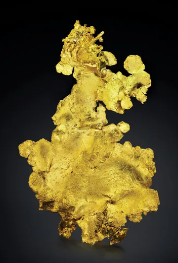
The county’s best gold specimens have a distinctly Sierra Nevada character: warm yellow native gold lodged in milky to iron-stained quartz, hackly masses and plates from oxidized vein material, rounded placer nuggets from ancient and modern gravels, and, at the highest level, sharp crystalline growths rather than mere bullion lumps. The geology behind them is structurally busy. Mother Lode veins are steep, discontinuous, pinch-and-swell quartz bodies in Jurassic slate and greenstone; the Georgia Slide style is different, with thin gold-quartz stringers spread through deeply weathered slate, schist, and amphibolite; the Big Canyon deposits add altered mafic rocks, pyritic metachert, and banded iron-formation to the story; and the Traverse Creek–Stifle Claim area contributes an entirely different collector aesthetic, with vesuvianite, grossular, diopside, clinochlore, tremolite, prehnite, opal, and serpentine minerals in and around rodingitic veins cutting serpentine.
Regional View
Country View
El Dorado County also occupies an unmatched position in American mining history. On January 24, 1848, James W. Marshall noticed gold in the tailrace of Sutter’s sawmill at Coloma on the South Fork of the American River, initiating the California Gold Rush and turning the county into one of the most intensely prospected landscapes in the West. Within a few years, placer miners had worked stream gravels and ancient channels, quartz mining had begun at Nashville and other early lode mines, and districts such as Placerville, El Dorado, Georgetown, Kelsey, Greenwood, Spanish Flat, Grizzly Flat, and Georgia Slide were known to miners far beyond California.
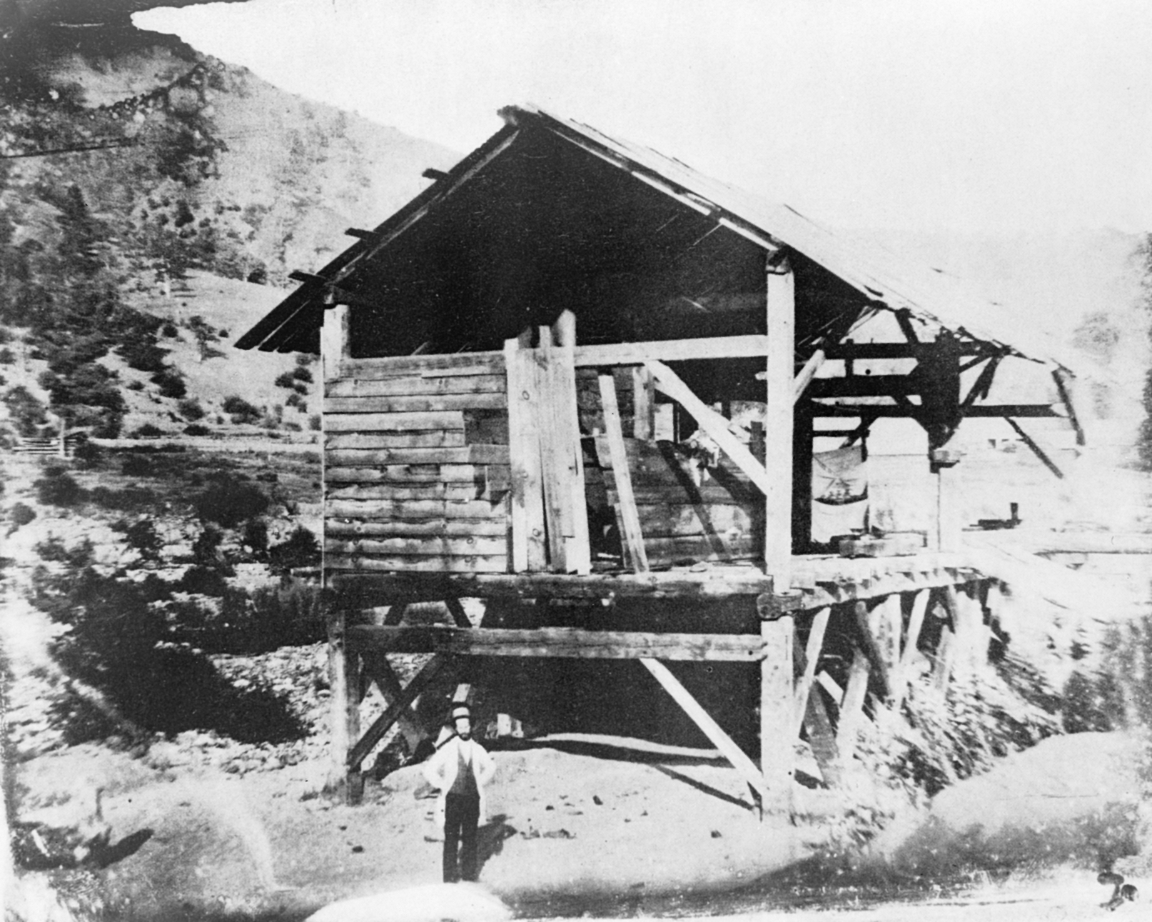
Photo: Wikimedia Commons
For modern collectors, El Dorado County is both a historic gold locality and a label that needs careful reading. A specimen marked simply “El Dorado County” may be a river nugget, a Mother Lode gold-in-quartz piece, a Traverse Creek vesuvianite, a chromite specimen from serpentine, or a copper-mineral specimen from the Pilot Hill area. The finest pieces are those with a precise mine or district: Grit Mine, Georgia Slide, Placerville district, Pacific Quartz Mine, Union-Church, Spanish Dry Diggings, Kelsey, Greenwood, Big Canyon, Slate Mountain, Pioneer-Lilyama, or Stifle Claim.
Search for specimens: View all specimens from El Dorado County, USA
El Dorado County’s collectible mineralization is not one deposit but a county-wide suite of related and contrasting systems. The classic gold deposits belong chiefly to the northern California Mother Lode and its adjacent East and West belts. In western El Dorado County, these belts run northward through the Nashville, El Dorado, Placerville, Garden Valley, Greenwood, Georgetown, and Georgia Slide areas, with the Mother Lode bending northeast toward Placerville and splitting near Garden Valley. The vein deposits are commonly described as low-sulfide gold-quartz veins: steeply dipping, structurally controlled quartz bodies carrying native gold with pyrite, arsenopyrite, and locally chalcopyrite, galena, sphalerite, pyrrhotite, ankerite, calcite, chlorite, sericite, talc, and mariposite.
The typical Mother Lode lode mine here followed tabular, pinch-and-swell quartz veins in black slate of the Upper Jurassic Mariposa Formation, with associated greenstone of the Logtown Ridge Formation nearby. The Pacific Quartz Mine in the Placerville district is an excellent example. Discovered in 1852, it became the principal lode mine of a district better known for Tertiary gravels. Its Pacific vein struck roughly northwest and dipped steeply northeast within slate, talc, and mariposite; ore shoots several hundred feet long and up to about 12 feet wide were developed, and the workings ultimately included a 700-foot shaft, multiple levels, and a long inclined winze from the 700-foot level. The ore was free-milling gold with auriferous pyrite and arsenopyrite in quartz, and the best specimens from this general style are gold in quartz rather than loose alluvial nuggets.
The El Dorado mining district, a few miles southwest of Placerville around Logtown and the old community of El Dorado, shows the same Mother Lode framework. Mariposa slate occupies the central part of the district, massive greenstone lies to the west, and granitic rocks, schist, and amphibolite lie to the east. Veins commonly ran five to ten feet thick and carried free gold and pyrite, with shallow workings yielding high-grade ore. The Union and Church mines were the most famous operations of the district; nineteenth- and early-twentieth-century reports treated them as major producers, and the Union is repeatedly singled out as one of the county’s largest gold mines.
The Georgia Slide district is a different and highly specimen-relevant kind of gold occurrence. Rather than a single large quartz vein, its “seam” deposit consisted of many thin gold-quartz stringers and veinlets cutting slate, schist, and amphibolite. The productive zone was several thousand feet long and hundreds of feet wide, and the upper part had been deeply weathered. Hydraulic mining could remove the soft decomposed wall rock, leaving quartz and gold to be sorted, sluiced, hand-crushed, or sent to small stamp mills. The richest parts occurred where veinlet systems intersected one another or met larger quartz veins. This style of deposit is a good explanation for why some El Dorado County gold specimens are crystalline, hackly, or delicate rather than simply rounded placer gold: the gold was concentrated in weathered, oxidized lode material before transport destroyed its form.
Tertiary auriferous gravels were another major source. The Placerville district’s ancient channels at Coon Hollow, Diamond Springs, Smith’s Flat, Texas Hill, White Rock, Spanish Hill–Green Mountain, and nearby channel remnants produced large amounts of placer gold. Other important Tertiary gravel fields lay around Georgetown and Grizzly Flat–Fairplay–Indian Diggings, and active stream placers were worked along the South, Middle, and North Forks of the American River and along the Cosumnes drainage. Collector material from these gravels ranges from fine gold and small “pickers” to nuggets, but most alluvial pieces lack the quartz matrix, crystal form, and mine-specific provenance that elevate the best cabinet specimens.
The Big Canyon area west of the main Mother Lode adds a more complex gold environment. USGS work described gold deposits in metamorphosed mafic volcanic and intrusive rocks, pyritic metachert, and lean banded iron-formation within the Bear Mountains ophiolitic mélange, west of a major fault zone. There, gold occurred in faulted and brecciated basaltic metatuff and metadiorite with pyrite-carbonate-albite alteration, and also in seemingly stratiform pyritic metachert and adjacent altered mafic rocks. The Big Canyon and Vandalia mines are the key names from this setting, and the published interpretation emphasizes metamorphic, CO2-rich hydrothermal fluids, sulfidation reactions, and structural preparation of reactive mafic host rocks.
Mining history in the county unfolded rapidly after 1848. Initial placer work followed the South Fork American River and nearby tributaries after Marshall’s discovery at Coloma. By 1851, lode mining had begun at Nashville, often cited as one of the county’s first quartz-mining ventures. During the 1850s and 1860s, miners pursued shallow high-grade quartz veins, ancient river gravels, residual seam deposits, and hydraulic ground. Hydraulic mining was curtailed by late-nineteenth-century regulation, after which lode mining became the chief source of recorded production, although dredging briefly revived placer output in the late 1930s. From 1880 through 1959, published federal compilations record 1,267,700 ounces of gold mined in El Dorado County, with systematic records after 1903 dividing production between placer and lode sources.
Operators changed constantly, as was typical of the Mother Lode. The Pacific Quartz Mine operated heavily from the 1850s into the 1880s, was idle for long stretches, and was later folded into the Placerville Gold Mining Company’s large block of lode and placer claims. The Church, Union, Pacific, Sherman, Big Canyon, Mount Pleasant, Pyramid, Sliger, Taylor, Zantgraf, Grit, Darling, Vandalia, Nashville, and numerous smaller mines all appear in state or federal records. The Pioneer-Lilyama mine near Pilot Hill represents a different commodity suite, a copper-gold-silver mine with azurite, malachite, chalcopyrite, bornite, brochantite, covellite, chalcanthite, galena, magnetite, pyrite, quartz, calcite, garnet, epidote, and vesuvianite documented from the locality.
The serpentine-hosted collecting localities around Traverse Creek and the Stifle claims are among the county’s most important non-gold specimen sites. Near Georgetown, serpentine along Traverse Creek is cut by rodingitic veins and related calcium-rich assemblages. Adolf Pabst’s 1936 study of vesuvianite from Georgetown described veins scattered over several hundred acres, most on a small hill west of Traverse Creek, with vesuvianite as the dominant mineral and grossular, hessonite, diopside, clinochlore, prehnite, tremolite, and opal as associated species. The vesuvianite ranges from common yellow-green granular to massive material to colorless, acicular, darker green, violet, and purple crystals lining vugs. Pabst measured 38 vesuvianite crystals and recorded multiple habits and color groups, making the locality a serious mineralogical site rather than a mere rockhound stop.
Collecting access today is mixed and must be approached conservatively. Much of the historic mine ground in western El Dorado County is private property, patented mining land, municipal property, or covered by active or historical claims. The Marshall Gold Discovery State Historic Park preserves the discovery site and is not a mineral-collecting locality in the specimen sense; recreational gold panning is a managed interpretive activity at designated areas and does not imply permission to dig, metal-detect, or collect specimens from cultural resources. Eldorado National Forest lands include rock and mineral collecting opportunities, but closures, special designations, sensitive botanical areas, mining claims, private inholdings, and local restrictions matter. Traverse Creek is also a Botanical Special Interest Area with serpentine soils and sensitive plant communities, so low-impact, legal, surface-level collecting and strict respect for posted rules are essential.
The most famous pocket-style find from the county is the Fricot Nugget from the Grit Mine at Spanish Dry Diggings. Although commonly called a nugget, it is best understood as a crystalline gold mass from a lode environment rather than a smoothed stream nugget. The Grit Mine was a Mariposa slate-hosted vein deposit with quartz and calcite veins, parallel veins reported up to about 20 feet thick, coarse pyrite, and weathered seam-style material near the surface. The Fricot specimen—about 201 troy ounces and now in the California State Mining and Mineral Museum—sets the standard by which all El Dorado County crystalline gold is judged.
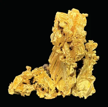
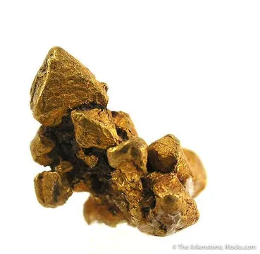
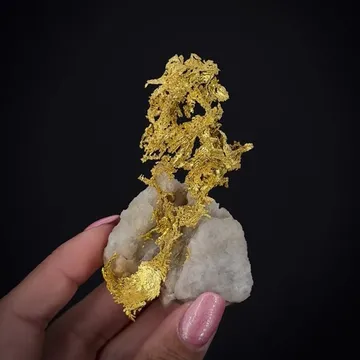
Gold from El Dorado County occurs as placer dust, pickers, and nuggets in the American and Cosumnes river systems and in Tertiary channels, but the collector-grade material is the native gold in quartz and crystalline gold from Mother Lode and seam deposits. In the Placerville, El Dorado, Kelsey, Greenwood, Georgetown, Georgia Slide, Spanish Dry Diggings, and related districts, gold is associated with milky quartz, iron oxides after sulfides, pyrite, arsenopyrite, calcite, ankerite, slate, schist, and greenstone. Ordinary pieces are small rounded alluvial grains or gold-speckled quartz; better specimens show visible metal with attractive contrast against white quartz; top pieces show crystalline leaves, wires, octahedral or arborescent growth, or a precise old-mine provenance such as Grit Mine, Georgia Slide, Pacific Quartz Mine, Placerville district, or Spanish Dry Diggings. The county’s specimen identity is anchored by the Fricot Nugget, a 201-troy-ounce crystalline mass from the Grit Mine, and by the long tradition of gold-in-quartz pieces from Kelsey, Placerville, and other Mother Lode workings.
Beyond gold, El Dorado County has a surprisingly broad mineral record. Traverse Creek and the Stifle claims are noted for vesuvianite in yellow-green, pale, violet, purple, granular, prismatic, and acicular habits, with grossular, hessonite, diopside, clinochlore, prehnite, tremolite, opal, calcite, and serpentine minerals in the same calcium-rich vein system. The county name is attached to el doradoite, an old trade name for blue quartz or chalcedony, originally described from El Dorado County and not a modern valid species. Spanish Flat’s Darling Mine has documented calaverite, an uncommon gold telluride occurrence within the county. Slate Mountain is known for phosphate minerals including crandallite-group material and hinsdalite. Serpentine belts near Georgetown, Coloma, Shingle Springs, Latrobe, Marble Valley, and the Pilliken area yielded chromite; Pilot Hill’s Pioneer-Lilyama mine adds the county’s strongest copper-mineral suite, with azurite, malachite, brochantite, chalcanthite, chalcopyrite, bornite, covellite, tetrahedrite-group minerals, galena, magnetite, pyrite, garnet, epidote, quartz, and calcite.
El Dorado County labels deserve careful scrutiny because the county name is famous, broad, and commercially attractive. A label reading only “El Dorado County, California” is much less informative than one naming Placerville, Kelsey, Georgia Slide, Grit Mine, Spanish Dry Diggings, Pacific Quartz Mine, Pioneer-Lilyama, Stifle Claim, or Traverse Creek. Fine gold-in-quartz with a precise old label commands a different level of collector interest than loose placer gold with only a county attribution.
Gold specimens from the county should be judged first for natural form and provenance. Placer nuggets should show the expected smoothing, edge rounding, impact marks, and compactness of transported gold. Lode gold-in-quartz should show believable penetration into the quartz or oxidized vein material rather than superficial metal sitting unnaturally on the surface. Acid-cleaned quartz is common in the gold market generally; bright white quartz and exposed gold are not automatically suspicious, but overly etched, brittle, or unnaturally “opened” pieces should be examined under magnification. Composited gold-in-quartz and repaired specimens exist in the broader natural-gold trade, so high-value El Dorado County pieces merit magnification, weight comparison, matrix inspection, and, where possible, a chain of custody.
The most locality-specific mislabelling issue is the old “California emerald” tradition around Georgetown and Traverse Creek. Green gemmy material from the Stifle/Traverse Creek area has historically been confused, marketed, or rumored as emerald, but the documented collector minerals there are vesuvianite, grossular, diopside, and related calc-silicate minerals, not emerald beryl. A specimen sold as “emerald from Georgetown” should be treated as suspect unless independently tested; a correct label reading vesuvianite or grossular from Traverse Creek is both more honest and more mineralogically interesting.
Condition problems vary by material. Gold in quartz may be bruised by mining, crushing, trimming, or later acid work; placer nuggets may be polished or tumbled, which reduces mineral-specimen value even if bullion value remains. Vesuvianite and grossular from Traverse Creek are often small, vuggy, and partly massive, and crystals may be fractured out of tough rodingite. Serpentine-associated specimens can contain fibrous amphibole or serpentine-group material; avoid generating dust, do not saw or grind suspect material without proper controls, and store friable fibrous pieces in boxes rather than loose trays. Copper sulfates such as chalcanthite from mine environments are water-soluble and should be kept dry, while iron-stained quartz and sulfide-bearing gold ores should be stored where humidity will not accelerate oxidation.
In current market terms, El Dorado County gold is available but stratified. Small placer nuggets and modest gold-in-quartz pieces appear regularly, often with vague Gold Country or county labels. Strong crystallized gold, attractive leaf or wire gold in quartz, and specimens tied convincingly to old districts or mines are much scarcer. Traverse Creek vesuvianite and associated minerals are obtainable, but the best old green, violet, or well-crystallized examples are far less common than massive serpentine or small field-collected fragments. The county rewards collectors who buy the label as much as the mineral.
On a cold January morning in 1848, the most consequential specimen ever noticed in El Dorado County was not a cabinet piece but a few shining flakes in moving water. James W. Marshall was building a sawmill for John Sutter at Coloma, on the South Fork of the American River, when he inspected the tailrace and saw metal in the ditch. Henry William Bigler’s diary preserved the date that later settled the chronology: January 24, 1848. The surviving recollections have Marshall caught by something “shining in the bottom of the ditch,” a phrase that still feels appropriately small for an event that emptied farms, ports, ships, shops, and households across the world. The place itself was not a mine, not yet a district, not even a mineral locality in the collector’s sense. It was wet lumber work in a Nisenan valley, and within months it became the hinge on which California’s history turned.
The first rush was for loose gold, but El Dorado County quickly taught miners that the yellow metal had more than one home. Streams were panned and sluiced first; then ancient river channels, perched above modern drainages, were driven into, hydraulicked, and drift-mined; then quartz veins were followed underground. At Georgia Slide, the distinction between placer and lode became wonderfully blurred. The deposit was still in place, yet so deeply weathered that the miners attacked it with hydraulic methods, washing away decomposed slate, schist, and amphibolite to leave quartz stringers and gold. Reports describe a zone thousands of feet long and hundreds of feet wide, not a single grand vein but a mesh of narrow gold-bearing quartz seams. When good quartz with gold appeared, miners hand-sorted it and crushed it in mortars; larger blocks went to stamp mills. This was specimen country by accident: the same deep oxidation and residual concentration that made the ground mineable could leave gold in crystalline, delicate, and pockety forms.
The Grit Mine at Spanish Dry Diggings gave El Dorado County its legendary showpiece. Deep in the mine, in a mud pocket within the old lode ground, William Russell Davis found a mass of crystallized gold that weighed about 201 troy ounces. It later became known as the Fricot Nugget after Jules Fricot, the Grass Valley buyer who paid far more than simple melt value and sent it into the world as a marvel. The specimen went to Paris for the 1878 Exposition, then disappeared into storage for decades before resurfacing in a safe-deposit box. Today it is displayed at the California State Mining and Mineral Museum. It is usually called a nugget, but every serious gold collector knows why that word is imperfect: it is not primarily a rounded stream-worn lump, but an arborescent, crystalline mass of native gold, the sort of object that proves a gold specimen can be mineralogy, sculpture, and history at once.
Traverse Creek tells a quieter but equally collector-rich story. In the 1920s and 1930s, green crystals from near Georgetown reached mineral dealers under enticing names, and the Stifle claims became associated with the romantic phrase “California emeralds.” Adolf Pabst went to the locality, examined the veins, and gave the material a far better identity. The main veins lay in a serpentine belt along Traverse Creek, with the productive ground scattered over several hundred acres. In the main “gem” pit on West Hill, a vein three feet or more thick had been worked to a depth of 15 feet and for 50 feet along strike. Pabst recorded yellow-green vesuvianite as the common material, but also colorless, green, violet, and purple crystals, some lining vugs and some conspicuously zoned. He measured 38 vesuvianite crystals and divided them into groups by color, habit, and size. For collectors, the charm of Traverse Creek is precisely that correction: what began as a gemstone rumor became a serious vesuvianite locality with its own crystal forms, color causes, and associations.