

Silver Plume, Colorado — classic silver-lead-zinc district famed for galena, sphalerite, and ruby-silver minerals; prized ore-mineral specimens with proven pro…
Key facts
Silver Plume is one of the classic silver-lead-zinc camps of Colorado’s Front Range: a steep, high-elevation mining town on Clear Creek, where the productive veins climb the south faces of Republican and Sherman Mountains immediately above the roofs of town. For collectors, the name belongs less to a single mine than to a compact cluster of lodes—Pelican, Dives, Dunkirk, Seven-Thirty, Terrible, Dunderberg, Payrock, Mendota, Diamond Tunnel and related workings—whose ores made the Georgetown–Silver Plume district one of Clear Creek County’s great silver producers.
Geologically, Silver Plume sits in the Colorado Mineral Belt, where older Proterozoic schists, gneisses, migmatitic rocks, and the famous Silver Plume Granite were cut by younger Tertiary porphyry dikes and mineralizing fissures. The silver-rich veins north of town are best understood as hydrothermal fissure-vein systems, dominated by galena, sphalerite, pyrite, quartz, siderite and other brown carbonates, with a collector’s suite of silver sulfosalts and silver-copper sulfides in favorable pockets. The district also gives its name to the Silver Plume Granite, a major Middle Proterozoic granite unit known far beyond mineral collecting.
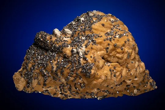
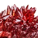
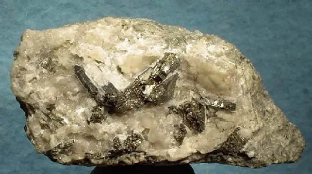
The best Silver Plume specimens are not “showy Colorado pegmatite” pieces; they are ore-mineral specimens with a very different aesthetic. Expect pale to white vein quartz, brown siderite or carbonate, sharp metallic galena, dark reddish-brown to amber sphalerite, pyrite, chalcopyrite, black tetrahedrite-group minerals, ruby-silver species such as pyrargyrite and proustite, and rare silver-copper phases such as jalpaite. The most desirable pieces preserve open-space crystallization: lustrous sphalerite and galena in quartz, small but vivid ruby-silver crystals, metallic silver species in vugs, or old-time massive sulfide specimens with reliable mine-level provenance.
Regional View
Country View
Silver Plume’s collector importance is sharpened by scale. This is not a sprawling anonymous district: the most productive silver-lead-zinc ground lay in a remarkably concentrated zone north of the town, and the old wagon road now followed by the 7:30 Mine Trail passes through the physical remains of that development. Mine dumps, tramway routes, tunnel portals, mills, legal boundaries, and old claims are crowded into the gulches above town, giving Silver Plume specimens a unusually strong sense of place.
Search for specimens: View all specimens from Silver Plume, USA
Silver Plume lies in western Clear Creek County, Colorado, at about 9,100 feet elevation on the Interstate 70 corridor west of Georgetown. In mineralogical usage, “Silver Plume” usually refers to the Silver Plume portion of the Georgetown–Silver Plume, or Griffith, mining district rather than merely the incorporated town. The principal specimen-producing mines were on the steep south slope of Republican Mountain and in the gulches immediately north and west of town, especially Cherokee Gulch, Snowdrift Gulch, and Brown Gulch.
The bedrock setting is a classic Front Range assemblage. The older country rocks are Early Proterozoic metasedimentary and metavolcanic rocks—commonly described historically as the Idaho Springs Formation—together with gneissic and migmatitic rocks. These were intruded by Mesoproterozoic granitic bodies of the Berthoud plutonic suite, including the Silver Plume Granite, and later cut by Tertiary dacite, quartz monzonite porphyry, granite porphyry, alaskite and related dikes. Modern mapping of the Georgetown quadrangle places the district’s ore deposition late in a 43 to 35 Ma intrusive episode, tying the vein mineralization to the younger Colorado Mineral Belt magmatic history rather than to the ancient granite itself.
The ore bodies are fissure veins and mineralized dike zones. The district contains two broad mineralogical styles: silver-lead-zinc veins and pyritic gold veins. At Silver Plume proper, especially north of town, the silver-lead-zinc type is dominant. Its common ore minerals are galena, sphalerite and pyrite, with chalcopyrite, tetrahedrite-group minerals, polybasite, ruby-silver minerals, native silver, acanthite and other silver species in richer zones. Quartz and brown carbonates, especially siderite and related carbonate gangue, are the principal non-ore vein minerals. The gold-bearing veins, more important in the belt between the silver zones, are dominated by pyrite, chalcopyrite and quartz and are less characteristic of the specimens ordinarily labeled Silver Plume.
Mining began in the larger Georgetown region after the 1859 gold rush, but Silver Plume’s great importance followed the 1864 recognition of rich silver ores in the Argentine district and the subsequent rush to silver lodes around Georgetown and Silver Plume. By the 1870s, the district had become a leading silver producer; by 1880, Georgetown–Silver Plume was the principal silver-producing district in Clear Creek County. Silver-lead mining reached a peak in the 1890s, then gradually declined, with zinc becoming an increasingly important part of the metal output after 1903 and during the World War I and World War II periods. Between the wars, much of the silver-base-metal ground was idle or worked only intermittently.
The Pelican and Dives mines were among the most celebrated properties on Republican Mountain. Their overlapping lodes, claims, and underground workings produced rich argentiferous ore but also years of litigation and physical confrontation before consolidation brought a measure of order. The related Pelican-Dives system was later connected by major tunnels and became one of the defining mine complexes of the Silver Plume hillside.
The Seven-Thirty Mine, high in Brown Gulch, was another major producer. It was located about 1870, later enlarged by acquisition of additional claims, and transferred in 1896 to the owners of the Dives-Pelican mine. Contemporary summaries gave its production before and through 1896 at approximately $1,868,720.97. Its name is traditionally explained by the long climb required of the miners: the shift could begin at 7:30 a.m. rather than 7:00 a.m. because the men had to walk so far to reach the workings.
The Payrock Mine is especially important to mineral collectors because of rare silver-copper sulfides. Its dump lay above the 7:30 Mine Trail near Snowdrift Gulch, and a tramway once carried material down to the Payrock mill on the valley floor. Early twentieth-century reporting credited the mine with about $2,000,000 in production, chiefly in silver. Later mineralogical work on old Payrock material confirmed significant jalpaite in association with galena, honey-yellow sphalerite, pyrite, mckinstryite and covellite, making Payrock one of the most scientifically interesting Silver Plume sources.
The Diamond Tunnel was one of the great engineering arteries of the camp. Begun in 1869 and reportedly connected with early diamond-drill work, it was driven northwestward from near the base of Republican Mountain and eventually reached roughly 3,100 feet by the turn of the twentieth century. It provided access to or drainage for important properties including Corey City, Pelican, Dives and portions of the Seven-Thirty workings. Such long tunnels mattered because hauling dense lead-silver ore down the steep mountain by wagon was expensive, slow, and dangerous; the tunnel system let operators move ore through the mountain rather than down exposed roads.
Collecting today must be approached with restraint. The historic 7:30 Mine Trail follows a nineteenth-century wagon road managed as a public right-of-way by Clear Creek County, but the mining claims and much of the ground crossed by the trail are private property. Old tunnels, shafts and adits are dangerous because of bad air, rotted timbers, water, unstable rock and hidden openings. Loose dump material visible from the trail is part of a historic landscape, not an invitation to dig. Serious collectors should treat Silver Plume primarily as an old-specimen locality unless they have explicit permission from the relevant land and mineral-rights holders.
Quartz from Silver Plume is the principal gangue of the silver-lead-zinc veins rather than the main show mineral, and the better specimens are valued for what the quartz carries: dark red-brown or amber sphalerite, galena, pyrite, chalcopyrite, siderite, baryte, tetrahedrite-group minerals, polybasite and ruby-silver species in vugs and seams. It ranges from pale, massive vein quartz to colorless or white open-space crystals lining small cavities; individual crystals are usually modest, while matrix pieces can reach hand-specimen and small-cabinet size. Good Silver Plume quartz pieces show clean contrast, open vug structure, and intact sulfide or sulfosalt associations; ordinary pieces are merely white vein quartz with scattered sulfide blebs from the dumps.
Other documented minerals from Silver Plume and the immediately surrounding mines include acanthite, native silver, anglesite, ankerite, arsenopyrite, baryte, bournonite, calcite, chalcocite, chalcopyrite, coloradoite, covellite, dawsonite, dyscrasite, enargite, epsomite, fizélyite, galena, goslarite, gypsum, hydromagnesite, hydrozincite, jalpaite, kaolinite, mckinstryite, muscovite, nagyágite, pearceite, petzite, polybasite, proustite, pyrargyrite, pyrite, pyrostilpnite, scheelite, siderite, smithsonite, sphalerite, stephanite, stibnite and tetrahedrite-group minerals. The locality is also historically important as the namesake and type area for Silver Plume Granite. Among mineral species, the most collector-significant rarities are the silver-copper sulfides from Payrock and nearby mines, especially jalpaite and mckinstryite, and the silver sulfosalts—polybasite, pyrargyrite, proustite and related dark metallic or ruby-red species—that mark the richer pockets of the old silver veins.
The main authenticity problem with Silver Plume specimens is locality precision. Old labels may say “Silver Plume,” “Georgetown,” “Georgetown District,” “Pelican-Dives,” “Dives-Pelican,” “Payrock,” “Mendota,” “Terrible,” “Dunkirk,” “Seven-Thirty,” “Illinois,” or simply “Clear Creek County,” and those labels are not interchangeable if a specimen is rare or scientifically important. A galena-sphalerite-quartz specimen from the broader Georgetown district is plausible under a Silver Plume label, but a jalpaite, mckinstryite, pyrargyrite or native-silver piece deserves a mine-level provenance whenever possible.
No widely recognized modern fake industry is associated with Silver Plume, but misidentification is common. Dark metallic silver minerals in this district can be difficult to distinguish by sight: acanthite, jalpaite, chalcocite, polybasite, pearceite, tetrahedrite-group minerals and tarnished native silver may look deceptively similar in hand specimen. Published work on Silver Plume jalpaite emphasized that polished-section reflectivity, etch behavior and even visual appearance can fail to separate jalpaite cleanly from acanthite; X-ray methods were the decisive tool. For valuable specimens labeled jalpaite, mckinstryite, pearceite, petzite, nagyágite, fizélyite or coloradoite, analytical confirmation is appropriate.
Condition issues are typical of old sulfide-vein material. Galena is soft and easily cleaved; bright cube faces and edges may be bruised. Sphalerite can be chipped or contacted, especially where it occurs as complex modified crystals in quartz. Siderite and other brown carbonates may be etched, iron-stained or crumbly. Ruby-silver minerals are light-sensitive and can darken; pyrargyrite and proustite should be stored away from strong light. Native silver and acanthite may tarnish, and silver-copper sulfides should be handled gently because fresh surfaces and old tarnish can be part of the specimen’s historical character.
Specimens from the classic Silver Plume mines are not abundant on the modern market. Common small pieces of quartz with pyrite, galena or sphalerite still appear from time to time, often as old Colorado collection material. Well-labeled mine specimens from Payrock, Seven-Thirty, Pelican-Dives, Terrible, Mendota or Diamond-related workings are scarcer. The strongest demand is for old labels, crystallized sulfide associations, ruby-silver specimens, confirmed jalpaite or mckinstryite, and pieces that can be tied to the famous nineteenth-century producing mines rather than only to the town name.
The hill above Silver Plume is almost too steep for the amount of history it holds. The 7:30 Mine Trail climbs what was once a wagon road, a practical necessity in a camp where men, timber, machines and food had to go uphill before ore could come down. The road itself became part of the economics of the Pelican Mine. In 1872, the first stretch was built at an estimated cost of $3,600 under the design of George Marsh, a Georgetown surveyor. The calculation was brutally simple: the Pelican alone was producing 60 tons of ore per week, and packing that ore down to Silver Plume had cost $10 per ton. A road could save roughly $600 per week, $2,400 per month, and $28,000 per year. In a camp where veins were narrow, lawsuits expensive and winters unforgiving, road engineering was ore dressing by another name.
Three years later, in October 1875, Jefferson Davis—former president of the Confederate States of America—traveled the same road as a guest of the Dives and Coldstream mine owners. The old accounts say he admired the “picturesque road” and the “skillful” engineering. It is a strange image: Davis on the switchbacks above Silver Plume, looking across a mountainside cut by claims, tunnels and ore roads, while below him the camp was still raw with one of the West’s most bitter mining feuds.
That feud centered on the Pelican and Dives mines. The claims crossed and overlapped along Cherokee Gulch and the slopes of Republican and Sherman Mountains, and both sides believed the other was taking ore from ground that belonged to them. The legal geometry was a nightmare. Early claims could be 50 feet wide and 1,500 to 2,500 feet long, but veins do not obey survey lines. A rich fissure could wander, split, reappear, or lie in a mineralized zone broad enough to make the old apex rules absurd. Attorneys, judges, geologists and surveyors became nearly as central to the business as miners.
On May 20, 1875, the dispute turned murderous. Sheriff Baily assembled a posse to serve an injunction against the Pelican side. Jackson Bishop, a Dives lessee with a violent reputation, wanted to be deputized and was refused. He followed anyway. When the writ could not be served that morning, Bishop snapped, telling the sheriff, “I will get law for myself.” On the road back toward Georgetown he threatened bystanders, forced an unarmed John Fillius to dismount and plead for his life, then encountered Jacob Snider, one of the Pelican owners, riding unarmed with mail for the miners.
Snider tried to flee back into Georgetown. Bishop chased him, fired once at the edge of town, missed, then caught him at Clark’s Livery Stable near Alpine and Rose streets. Snider’s way was blocked by a buggy. Bishop struck him with the butt of his pistol; when Snider fell, one foot still caught in the stirrup, Bishop shot him in the back of the head. He then rode out toward the Dives Mine, bragging to men in a wagon that he had killed Jake Snider.
The story grew even darker above the mines. About an hour after the killing, Bishop appeared at the Denver Lode cabin above the Pelican and Dives workings. H. D. Steele later said Bishop wanted food and made clear he intended to have it. He was carrying six revolvers and a repeating long-range rifle. He ate outside, watched the Pelican, and said he meant to kill twenty more men if it took all season. Later, crouched behind a rock and then positioned near the Pelican boardinghouse, he fired at workers moving inside. He hit no one, but one shot reportedly tore a man’s clothing. At dusk he rode away toward Empire and disappeared. He was never caught. The USGS map later preserved the memory in the name “Bishop Rock.”
Brown Gulch tells a different kind of Silver Plume story: not violence between men, but the violence of terrain. The Seven-Thirty Mine, high in the gulch, was said to owe its name to the long walk miners had to make before they could begin work. The mine was located about 1870, later folded into the Dives-Pelican ownership, and by 1896 had credited production approaching $1.87 million. The largest mine at the base of Brown Gulch was the Terrible, reached through the Union and Silver Ore tunnels; the Dunderberg sat partway up the eastern side. For much of the late nineteenth century, these major properties were owned by British investors. Above the town, mining was international capital, local labor, and steep Colorado topography compressed into one gulch.
Silver Plume also remembers February 12, 1899. By then the hillsides north of town were nearly bare because trees had been cut for mine timber, fuel and cabin building. Early that morning, avalanches came down Cherokee Gulch and Willehan Gulch. Ten people died: Dominick DeStafano with his wife, son and daughter; the brothers Joseph, Peter and John Tondini; Gerondo Guenzi; G. Bietto; and Enrico Novaria. All were of Italian descent and had been living in hillside cabins. Three other Italian men—Antonio Migretto, Antonio Maleano and Guiseppe Corcunio—were dug alive from the slides by rescuers from Silver Plume and Georgetown, who used scattered lumber as clues to where cabins had been crushed. The dead were buried together in the Silver Plume cemetery beneath a public monument to the “Ten Italians, Victims of an Avalanche.”
Another monument stands high above the valley for Clifford Griffin, son of Alfred Griffin of Brand Hall, Shropshire, England. The inscription records that he was born July 2, 1847, died June 19, 1887, and was buried near that spot at his own request. His brother Heneage Griffin owned and managed the Seven-Thirty properties for years, but Clifford became the figure around whom folklore gathered. Stories claimed he played a ghostly violin, dug his own grave, came west for a lost fiancée, or was murdered. The coroner’s inquest gave the harder fact: he died by suicide in a cabin at the Seven-Thirty Mine on the morning of June 19, 1887. On this mountain, even the romantic legends are pinned to mine names, dates and cabin sites.
The Diamond Tunnel adds the camp’s engineering counterpoint. Work began in 1869, and by May 1890 the Ashby tunnel nearby was already recorded at 1,610 feet. The Diamond was driven in fits and starts through the 1870s and eventually extended about 3,100 feet northwest into Republican Mountain by the turn of the century. It reached or served the Corey City, Pelican, Dives and even parts of the Seven-Thirty workings. A photograph from around the turn of the century shows a group preparing to tour the tunnel; the scene is almost genteel compared with what the tunnel meant underground—a long, expensive, strategic cut through the mountain to unlock veins that had already filled courts, mills, wagons and boardinghouses with conflict.
Josiah E. Spurr, George H. Garrey and Sydney H. Ball, “Economic geology of the Georgetown quadrangle (together with the Empire district), Colorado,” U.S. Geological Survey Professional Paper 63, 1908. The foundational federal report for the district, including the Silver Plume mining district, mine descriptions, production summaries, vein relationships and the early geology of the Georgetown quadrangle.
T. S. Lovering and E. N. Goddard, “Geology and ore deposits of the Front Range, Colorado,” U.S. Geological Survey Professional Paper 223, 1950. The major mid-century synthesis of Front Range ore deposits, including the Georgetown–Silver Plume district’s silver-lead-zinc veins, pyritic gold veins, host rocks and mineral assemblages.
Beth L. Widmann and Ulrike Miersemann, “OF-01-05 Geologic Map of the Georgetown Quadrangle, Clear Creek County, Colorado,” Colorado Geological Survey, 2001. Modern quadrangle mapping that places Silver Plume in the Proterozoic basement and Tertiary intrusive framework of the Colorado Mineral Belt.
S. H. Ball, “Pre-Cambrian rocks of the Georgetown quadrangle, Colorado,” American Journal of Science, 1906, summarized by the National Geologic Map Database Geolex entry for Silver Plume Granite. The naming source for Silver Plume Granite, describing the granite around Georgetown and Silver Plume and establishing the town as the source of the geologic unit name.
Donald Grybeck and J. J. Finney, “New occurrences and data for jalpaite,” The American Mineralogist, vol. 53, September–October 1968. The key mineralogical paper for Silver Plume jalpaite from the Payrock Mine, including old specimen provenance, associated minerals, X-ray data, density, microhardness, and the distinction from acanthite.
Colorado Geological Survey Open-File Report 96-4-08, field-trip guide to the Glenwood Springs area, including Silver Plume road-log notes. Useful for the Silver Plume Granite type-locality quarry and for concise interpretation of the district’s veins as distal epithermal, magmatic-hydrothermal mineralization associated with Tertiary intrusions.
Mindat, “Silver Plume, Clear Creek County, Colorado, United States”. Useful for coordinates, elevation, nearby mine localities and the compiled one-kilometer mineral list around Silver Plume.
Mindat, “Georgetown-Silver Plume Mining District, Clear Creek County, Colorado, USA”. The broad district-level mineralogical listing and summary for the Griffith / Georgetown–Silver Plume mining district.
Clear Creek County: 7:30 Mine Trail — Official trail page linking the interpretive PDFs for the historic wagon road, mines, lawsuits, avalanche, Diamond Tunnel, Payrock area and Seven-Thirty Mine.
Clear Creek County: Site 1, 7:30 Mine Trail general information — Best concise access and safety note: the trail is a public right-of-way, while adjacent claims are private and old workings are hazardous.
Clear Creek County: Site 2, Tunnels and Mills — Strong short account of the Ashby and Diamond tunnels and the Nashotah mill.
Clear Creek County: Site 4, Mines, Mining and Lawsuits — Clear explanation of the Pelican-Dives legal conflict and why claim geometry mattered.
Clear Creek County: Site 5, Snowdrift Gulch — Useful for the Payrock Mine dump, tramway, mill and reported production.
Clear Creek County: Site 6, The Dives Pelican Feud and the Murder of Jacob Snider by Jackson Bishop — The most vivid historical source for the Pelican-Dives feud and the 1875 killing.
Clear Creek County: Site 7, Avalanche — The local interpretive account of the February 12, 1899 avalanche tragedy.
Clear Creek County: Site 8, Heneage and Clifford Griffin — Background on the Seven-Thirty Mine’s Griffin family connection and Clifford Griffin’s mountainside grave.
Clear Creek County: Site 9, Brown Gulch and the 7:30 Mine — A concise history of the Seven-Thirty, Terrible and Dunderberg mines and the production summary for Seven-Thirty.
Western Mining History: Clear Creek County Colorado Gold Production — Accessible synthesis of Georgetown–Silver Plume history, production, bedrock geology and ore types.
Western Mining History: Clear Creek County Colorado Mining Districts — Useful district overview with vein classifications and references to detailed USGS treatments.
Town of Silver Plume — Local civic and historical context for the modern town within the Georgetown–Silver Plume National Historic Landmark setting.
National Geologic Map Database: Silver Plume Granite — The formal geologic-name entry for Silver Plume Granite and its origin from the town.