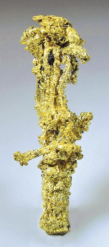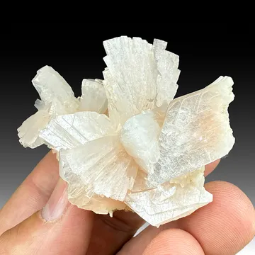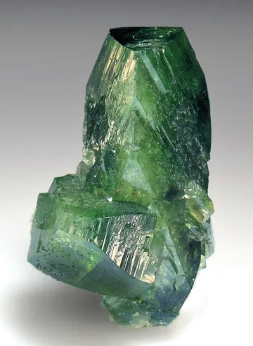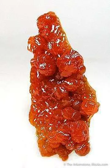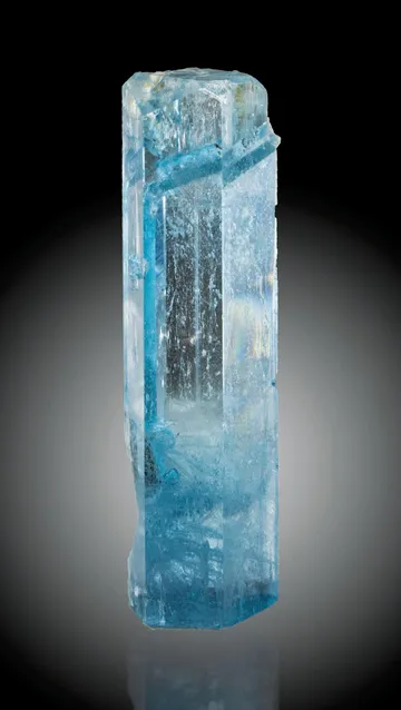




Boise County, USA - a diverse collecting locality with blue aquamarine from miarolitic granite, smoky quartz, fluorite, and historic placers with native gold.
Key facts
Boise County is one of Idaho’s great collector counties because it is not a single-locality story. It is a compact mineral province where three different collecting worlds overlap: the Boise Basin gold field, with placer gold and heavy-mineral concentrates derived from lode systems in the Idaho batholith; the Quartzburg–Grimes Pass lode belt, with gold, silver, base-metal sulfides and bismuth minerals; and the Sawtooth batholith miarolitic-cavity suite, a high-country granite assemblage famous for aquamarine, topaz, smoky quartz, zinnwaldite, fluorite, helvite-group minerals, unusual manganese-lithium silicates, and the type-locality mineral potassic-carpholite.
For specimen collectors, Boise County’s appeal lies in that breadth. Its historic placers supplied native gold and accessory black-sand minerals such as garnet, ilmenite, magnetite, zircon, monazite, columbite-series material, euxenite, and samarskite. Its lode mines added quartz, pyrite, arsenopyrite, galena, sphalerite, chalcopyrite, tetrahedrite-group minerals, stibnite, tetradymite, galenobismutite, and scarce sulfosalts such as owyheeite at the Crown Point mine in the Banner district. Its granitic pockets, especially in and around the Sawtooth batholith, produced the most recognizably “cabinet-specimen” material: blue aquamarine crystals, colorless topaz, smoky quartz, fluorite, microcline, albite, beryl, zinnwaldite, bertrandite, hellandite, hematite, apatite, and tiny but scientifically important fibrous potassic-carpholite.
The best Boise County specimens are not usually gaudy show pieces in the way of Deccan zeolites or Tsumeb carbonates. They have the quieter authority of a western U.S. field locality: a sharp blue aquamarine from miarolitic granite, a placer-gold piece with original Boise Basin provenance, a sulfide ore specimen from Quartzburg or Banner with a precise mine label, or a microscope-scale rare species from a documented Sawtooth pocket. In good examples, the label is almost part of the specimen: Boise County rewards collectors who care about geology, history, and provenance as much as color.
Regional View
Country View
The county’s mineralogical backbone is the Idaho batholith and its younger intrusive and volcanic relatives. In the Boise Basin, granitic rocks are cut by dikes, stocks, fracture zones, and the well-known Quartzburg–Grimes Pass porphyry belt, a northeast-trending structural and intrusive zone that focused many of the lodes. Erosion of those gold-bearing veins, followed by reworking of older gravels and stream deposits, made the placers that drew thousands of miners after 1862. In the Sawtooth batholith, volatile-rich granitic pockets formed a different kind of treasure: open cavities where late fluids crystallized gem beryl, topaz, mica, fluorite, and rare species on the walls of the granite.

Photo: Wikimedia Commons

Photo: Wikimedia Commons
Search for specimens: View all specimens from Boise County, USA
Boise County lies in west-central Idaho, with Idaho City as the historic center of the Boise Basin mining country. The classic Boise Basin district occupies roughly 300 square miles of low mountainous terrain drained chiefly by Mores Creek, Grimes Creek, Elk Creek, Granite Creek, and related tributaries of the Boise River system. The bedrock is dominated by granitic rocks of the Idaho batholith, principally biotite granite and granodiorite, cut by younger porphyritic intrusions, lamprophyres, pegmatites, and scattered volcanic and sedimentary units. For collectors, the important point is source and concentration: the lode veins supplied gold and heavy minerals, while repeated erosion, lake deposition, basaltic damming, and stream reworking concentrated that material into workable placers.
The major placer deposits were formed from weathered and eroded gold-quartz veins. Older auriferous gravels and Tertiary lake beds were later reconcentrated by younger streams, creating richer, more workable placers. The black sands in those gravels are a significant part of the county’s mineralogical interest. Bureau of Mines work on Boise Basin concentrates recorded magnetite, ilmenite, garnet, monazite, zircon, quartz and feldspar, and noted that near mineralized zones and pegmatite dikes the granitic rocks contributed appreciable ilmenite, garnet, zircon, monazite, and lesser magnetite. Fall Creek placer records also document columbite-series material, euxenite-(Y), samarskite-(Y), and native gold.
The lode deposits of Boise Basin are structurally tied to fracture and shear zones in the batholithic rocks. The Quartzburg–Grimes Pass porphyry belt is the most important named structure for collectors to remember. It trends northeast from the Quartzburg area toward Grimes Pass and beyond, and consists of a zone of deformation, intrusive porphyries, and mineralized fissures. The ores were chiefly gold-bearing quartz veins, but many contained pyrite, arsenopyrite, galena, sphalerite, chalcopyrite, tetrahedrite-group minerals, stibnite, bismuth minerals, and silver-bearing sulfosalts. The Gold Hill, Belshazzar, Mountain Chief, Crown Point, and other mines are therefore more than historical names; they are the source labels that separate ordinary Boise County ore specimens from worthwhile locality pieces.
The county’s mining history began explosively. Gold was found in the Boise Basin in August 1862, and miners returned in strength that autumn. Pioneerville, Centerville, Placerville, and Idaho City developed rapidly, and by 1863 the basin held tens of thousands of people by contemporary accounts. Early mining was by hand shoveling, rockers, sluices, and hydraulic methods. Ditches were built to bring water to bars and benches, and hydraulic mining began at Bishop’s Hill above Placerville in 1864. Shallow hand work could not reach much of the deeper creek gravel because of seepage and flat stream gradients, so later production shifted toward hydraulic mining and dredging.
Dredging became a defining chapter of the Boise Basin landscape. Experimental and early dredges worked Wolf Creek and Grimes Creek around 1898–1899. The Boston and Idaho Gold Dredging Company put a steam dredge to work near Warm Springs on Mores Creek around 1900; later electrically powered dredges worked Mores Creek and Elk Creek. A large 16-cubic-foot dredge on Elk Creek, begun in 1910, worked down Elk Creek and Mores Creek, then back upstream, before ceasing in 1918. Twentieth-century dredging continued through the 1930s and 1940s with companies including Moores Creek Dredging Company, Idaho-Canadian Dredging Company, Fisher-Baumhoff, Baumhoff and Marshall, and the Grimes Company. Many of the gravel ridges still visible around Idaho City and nearby drainages are dredge tailings rather than natural terraces.
The Sawtooth batholith represents a very different specimen environment. In the Boise County portion of that granite, collectors and researchers have documented miarolitic cavities ranging from microscopic openings to rare cavities more than a meter across. These pockets contain quartz, microcline, albite, beryl, topaz, fluorite, zinnwaldite, bertrandite, hellandite, hematite, apatite, and rare silicates. Potassic-carpholite, described as a new species in 2004, occurs near Centerville as late-stage white to straw-yellow fibrous tufts coating microcline in these cavities. The holotype came from this Boise County Sawtooth batholith occurrence, making the county important not only for gold-rush history but for modern descriptive mineralogy.
Zeolite collecting in Boise County is less famous than the Sawtooth pocket minerals or Boise Basin gold, but it is part of the county’s specimen picture. Gardena, a Highway 55 roadcut locality, is documented for zeolite minerals including mordenite, mesolite, stilbite-subgroup material, and thomsonite-subgroup material. Warm Springs Creek is recorded for chabazite and thomsonite-subgroup zeolites. These occurrences are best treated as small-vug and roadcut material: fine for systematic collectors, locality suites, and micromounts, but dependent on current exposure and land status.
Collecting access today is a patchwork. Much of the county is public land, but claims, private parcels, patented mine ground, historic sites, road rights-of-way, riparian rules, and agency closures matter. Casual rockhounding is generally possible on many public lands administered by the U.S. Forest Service or BLM, but collectors must verify whether a site is open, whether it is under active mining claim, and whether removing material is allowed. Panning by non-mechanized means is treated differently from powered or in-stream disturbance; suction dredges, powered sluices, and some non-powered equipment that alter streambeds require Idaho Department of Water Resources permitting and are subject to stream-specific rules. Historic mine workings should be treated as hazards and as cultural resources, not collecting invitations.
Boise County heulandite is best approached as a locality-suite zeolite rather than as the county’s dominant show mineral: collectors should expect small, pearly, tabular to platy heulandite-group crystals in cavity material, with the strongest pieces showing clean luster, separation, and contrast against associated white fibrous or radiating zeolites such as mordenite, mesolite, stilbite-subgroup material, or thomsonite-subgroup material. The county’s verified zeolite context includes Gardena roadcut material and Warm Springs Creek zeolite occurrences, while the Sawtooth batholith is also documented for heulandite-subgroup minerals; because stilbite and heulandite can be visually confused, especially as pale cream, peach, or tan plates, a good Boise County example is one with a precise old label, convincing crystal habit, and ideally analytical or expert confirmation.
Other minerals documented from Boise County make the county far richer than a single-species zeolite occurrence. The Sawtooth batholith suite includes beryl, aquamarine, topaz, smoky quartz, microcline, albite, fluorite, zinnwaldite, bertrandite, hellandite, hematite, apatite, helvite-group minerals, and potassic-carpholite, the latter described from near Centerville as a new mineral species. Boise Basin placer suites add native gold and black-sand species including garnet, ilmenite, magnetite, zircon, monazite, columbite-series minerals, euxenite-(Y), and samarskite-(Y). The lode districts add quartz, pyrite, arsenopyrite, galena, sphalerite, chalcopyrite, tetrahedrite-group minerals, stibnite, tetradymite, galenobismutite, and owyheeite, with Crown Point mine material in the Banner district especially attractive to sulfosalt specialists.
Boise County specimens live or die on locality precision. “Boise County” alone is acceptable for an old thumbnail or inherited suite, but better labels should say Gardena, Warm Springs Creek, Sawtooth batholith, Boise Basin, Idaho City district, Quartzburg district, Grimes Pass, Banner district, Crown Point mine, Gold Hill mine, Belshazzar mine, Mountain Chief mine, Fall Creek placers, Mores Creek, Grimes Creek, or another specific sublocality. The county contains multiple unrelated deposit types, so a loose “Boise County” label can conceal a great deal of ambiguity.
The commonest mislabelling risk is confusion between Boise County and the broader Boise area. “Boise” can mean the city, the county, the Boise Basin, the Boise River drainage, the Boise National Forest, or simply an old dealer’s regional shorthand. Ada County localities near Boise, Owyhee County zeolite and silver localities, Custer County Rat’s Nest heulandite-mordenite specimens, and Boise County material can all be blurred by casual labels. For heulandite in particular, be cautious: Idaho heulandite-mordenite specimens from the Rat’s Nest claim in Custer County are more familiar in the market than confirmed Boise County heulandite, and “Idaho zeolite” is not enough.
Condition issues vary by assemblage. Sawtooth batholith aquamarine and topaz crystals are often etched, contacted, or partly gemmy rather than fully transparent; these features are natural for much of the material and should not be dismissed as damage unless there are fresh chips or broken terminations. Miarolitic pocket specimens may have delicate attached mica, fluorite, bertrandite, or rare fibrous minerals that are easily lost in cleaning. Zeolite pieces from roadcuts and vugs commonly have bruised edges, soft fibrous coatings, and dusty cavities; avoid ultrasonic cleaning and aggressive brushing. Sulfide-rich lode specimens may contain pyrite, arsenopyrite, galena, tetrahedrite-group minerals, or bismuth minerals and should be kept dry, boxed separately, and handled with normal sulfide precautions.
Potassic-carpholite is not a display species in the ordinary sense. It occurs as minute fibrous tufts and is important because of its type-locality status and chemistry, not because it forms large crystals. Any specimen represented as potassic-carpholite from Boise County should have serious provenance, preferably from a known Sawtooth batholith pocket suite or a research-associated source. Ordinary field-collected white fibers on feldspar should not be assumed to be potassic-carpholite without analysis.
Native gold from Boise Basin remains collectible, but much of what appears on the market is placer gold with broad regional labels. Premium pieces are those with old collection provenance, mine or creek specificity, attractive form, and retained matrix or black-sand context. Modern panned gold from public or claim ground should be documented carefully, because legal access, claim ownership, and stream disturbance rules affect both collecting ethics and future resale confidence.
The Boise Basin story begins with a rumor that sounded almost too good to be useful: gold so abundant it could be found in the streams of the basin. In the summer of 1862, prospecting parties associated with Moses Splawn, H. Fogus, and George Grimes moved cautiously into the country north of the Boise River. On August 2, 1862, gold was found on Boston Bar near what became Centerville. The victory was brief and grim. A week later, on August 9, George Grimes was shot from ambush and killed. Later accounts disagreed over whether Native attackers or members of his own party were responsible, but the result was fixed into the map: Grimes Creek and Grimes Pass carried his name into mining history.
When better-equipped parties returned from Walla Walla that autumn, the rush became unstoppable. Pioneerville and Idaho City were founded on October 7, 1862. The numbers that followed still feel startling. A week’s prospecting yielded $2,000. Ordinary miners could hope for $8, $16, or $20 a day, while a few claims reportedly paid $100 to $200 a day. By mid-January 1863, Placerville had around a thousand people, and by the end of that month roughly 4,000 miners were in the basin. In the driest ground, men packed gravel in flour sacks to water and, if they had the stamina, could recover $50 to $60 a day with rockers.
Water determined everything. Placerville’s short season limited its early dominance, while Idaho City had water longer each spring and soon overtook its neighbors. In 1863, some eighty miles of ditches were dug in time for the placer season around Idaho City. On Elk Creek, an hydraulic giant—a high-pressure metal hose fed by a ditch—was already tearing down gold-bearing gravel; five men operating it were reported to recover $1,400 a week. By 1864, after a mild winter left too little snowpack, water became so precious that miners worked day and night while it lasted. More than thirty large fires lit separate claims visible from Idaho City, a night landscape of flame, gravel, water, and gold. Then the streams turned to mud: by early May around Placerville and early June around Idaho City, mining halted with some of the best ground still less than half worked.
The human scale of the rush was enormous. In 1863, Boise Basin still held around 16,000 people after the summer population had begun to thin, with more than 6,000 at Idaho City alone. For a time Idaho City surpassed Portland as the largest community in the Pacific Northwest. The mining camps were not simply rows of tents; they became towns with newspapers, lodges, businesses, and permanent ambitions. They were also volatile Civil War-era frontier places, where political tension, sudden money, road agents, shootings, and vigilante justice shaped daily life as much as picks and sluice boxes.
The later dredging chapter has its own machinery drama. Early dredges tried Wolf Creek and Grimes Creek around the turn of the twentieth century with mixed success. A Boston and Idaho Gold Dredging Company dredge near Warm Springs on Mores Creek ran until it sank in 1905. F. W. Estabrook then brought in hydroelectric power from the Payette River side, built transmission lines to Idaho City, Centerville, and Quartzburg, and pushed dredging into a more industrial phase. One dredge handled 40,000 to 100,000 cubic yards of gravel per month; another, with 16-cubic-foot buckets, reached a monthly capacity of about 200,000 cubic yards. The gold field that had begun with men carrying flour sacks of gravel to water had become a landscape of bucket lines, ponds, power lines, and tailings.
One of the strangest mineralogical footnotes is monazite. Boise Basin black sands were not merely waste; they contained heavy rare-earth phosphate grains shed from the batholith and associated pegmatitic rocks. In 1909 the Centerville Mining and Milling Company tried to recover monazite using gravity concentration and electromagnetic separation. A mill was built near Centerville, only to be destroyed by a forest fire a year later. Decades later, from 1946 through 1948, dredges operated by Baumhoff-Marshall and Idaho-Canadian saved part of their jig concentrates, stockpiled them, and shipped some to McCall for magnetic separation. One carload—40 tons—of monazite was sold from that effort.
Alfred L. Anderson, “Geology and ore deposits of Boise Basin, Idaho,” U.S. Geological Survey Bulletin 944-C, 1947 — The key federal treatment of Boise Basin geology, lode deposits, placers, and the structural setting of the district.
Samuel M. Ballard, “Geology and Gold Resources of Boise Basin, Boise County, Idaho,” Idaho Bureau of Mines and Geology Bulletin 9, 1924 — Foundational Idaho Geological Survey bulletin with map coverage and detailed early interpretation of Boise Basin geology and gold resources.
E. L. Jones Jr., “Lode mining in the Quartzburg and Grimes Pass porphyry belt, Boise Basin, Idaho,” U.S. Geological Survey Bulletin 640-E, 1917 — Classic report on the northeast-trending porphyry belt and the lode mines most relevant to quartz, sulfide, and sulfosalt collectors.
U.S. Bureau of Mines, “Boise Basin Monazite Placers, Boise County, Idaho,” RME-3129 — Detailed report on placer geology, dredging, black-sand mineralogy, and monazite recovery attempts.
Kimberly T. Tait, Frank C. Hawthorne, Joel D. Grice, John L. Jambor and William W. Pinch, “Potassic-carpholite, a new mineral species from the Sawtooth batholith, Boise County, Idaho, U.S.A.,” The Canadian Mineralogist, 42, 121–124, 2004 — Type-mineral description for potassic-carpholite, including its occurrence near Centerville in miarolitic cavities.
Michael A. Menzies and Russell C. Boggs, “Minerals of the Sawtooth Batholith, Idaho,” The Mineralogical Record, 24(3), 185–202, 1993 — Important collector-oriented publication on Sawtooth batholith pocket minerals, including aquamarine, topaz, and rare species.
Victoria E. Mitchell, “History of the Belshazzar and Mountain Chief Mines, Boise County, Idaho,” Idaho Geological Survey Staff Report S-08-3, 2008 — Useful mine-history report for two important Boise County lode properties.
Mindat: Boise County, Idaho, USA — Broad mineral and locality index for the county; especially useful for checking sublocality spellings and species lists.
Mindat: Gardena, Boise County, Idaho, USA — Specific locality page for the Gardena zeolite occurrence and its Highway 55 roadcut context.
Mindat: Crown Point Mine, Banner Mining District, Boise County, Idaho, USA — Locality reference for owyheeite and Banner district sulfosalt collecting.
“During the gold rush, Idaho City became the largest city in the Northwest” — KTVB — Short local-news feature on the Boise Basin gold rush and Idaho City’s boomtown scale.
“Idaho City’s Rich Gold Rush History Unveiled Through Preserved Landmarks | Bartell’s Backroads” — ABC10 — Recent historical video visiting Idaho City landmarks tied to the Boise Basin gold rush.
“Winter Read: The Light of a Hundred Fires: Chinese Experiences in Idaho’s Gold Rush Era” — Renae Campbell / Vimeo — Lecture-style media focused on Chinese communities and archaeological history in the Boise Basin gold industry.
Idaho Department of Lands: Rockhounding — Practical starting point for Idaho collecting rules, state endowment trust land, and public-land cautions.
Idaho Department of Water Resources: Small Scale Mining Permits — Current permitting information for suction dredges, powered sluices, and stream-channel disturbance.
BLM Idaho: Mining and Minerals — Federal overview of claims, casual use, suction dredging, and public-land mineral collecting in Idaho.
Idaho State Historical Society Reference Series: “Placer Mining in Southern Idaho, 1862–1864” — Compact, vivid account of the first Boise Basin placer rush and its early production.
Idaho City Historical Foundation: Basin of Gold — Local historical foundation resource on the discovery and settlement of the Boise Basin.
Boise County: Visit Boise County — County historical overview with useful context for Idaho City and the mining camps.
Boise Basin Museum — Visitor resource for mining machinery, Idaho City history, and gold-rush interpretation.
Western Mining History: Boise County Idaho Gold Production — Concise district-by-district summary of Boise County gold production and mining history.
Wikimedia Commons: Aquamarine from the Sawtooth Batholith, Boise County — Reusable photograph and specimen details for a documented Boise County aquamarine.
Wikimedia Commons: 1864 Map of Boise and Owyhee Mining Sections — Historic public-domain map showing the early mining geography of the region.